
Search Boxes
The search areas calculated by SearchWell include the traditional as well as search boxes based on the random points that can be generated.
Rapid Search Box
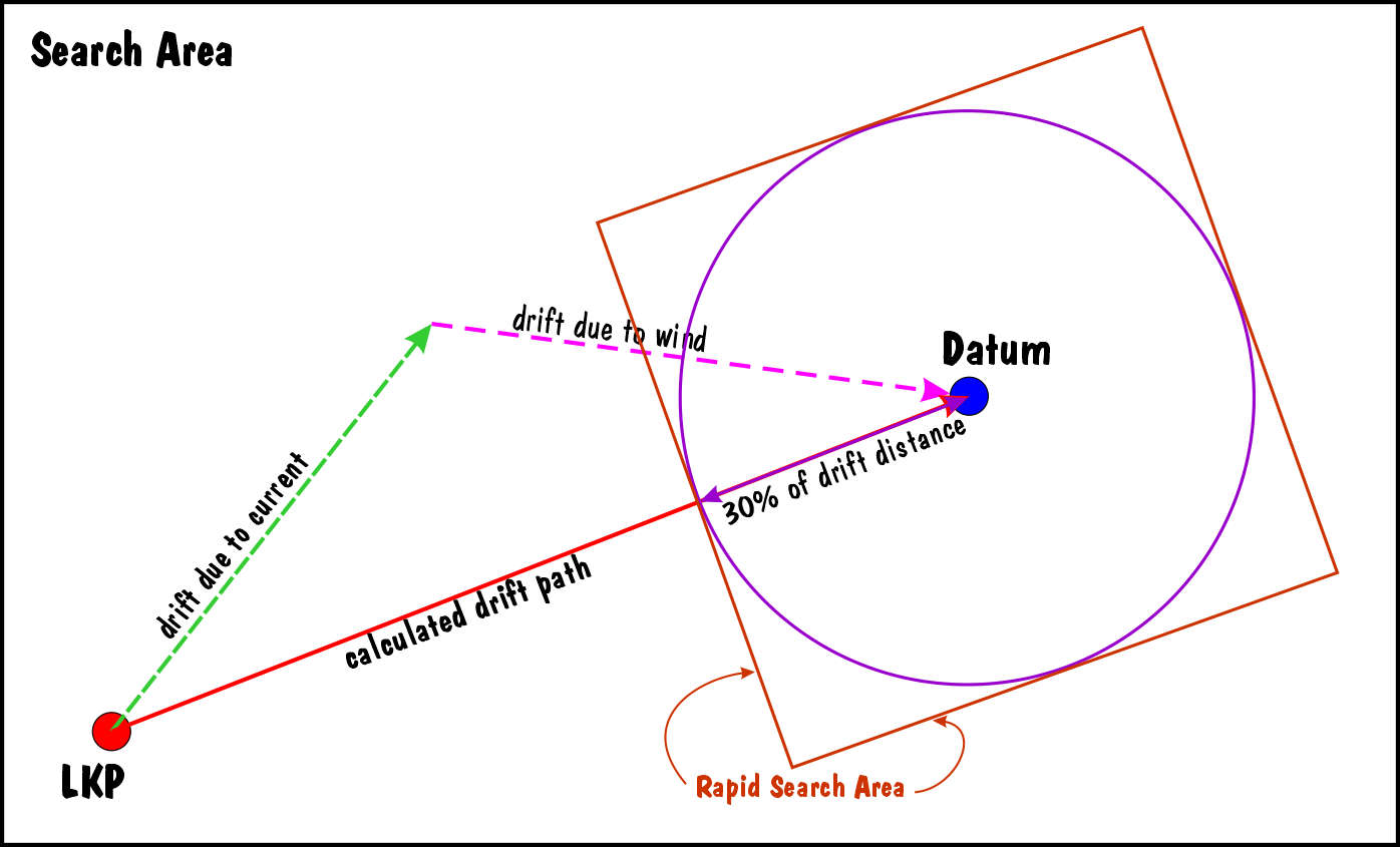
This is the first search area that is calculated - some say it should be used in the first hour of a search. The standard practice is to
•calculate one-third of the drift distance from LKP to the calculated Datum position
•draw a circle with this distance as the radius and the datum position as the centre
•draw a box around this circle
Extended Search Box
The Extended Search Box which is often used for a search that extends past 1 hour. It considers the leeway divergence angle (due to wind) as defined in the leeway table.
In SearchWell the process of calculating this search box is as follows :
1.calculate where the casualty would drift due to current only (the current vector). The point at the end of this line is where the current would push the casualty in the given time.
2.using the position calculated in step 1 to consider the effect of the wind (the wind vector) in combination with the divergence for the casualty type from the Leeway Table .
a.use the bearing along which the wind will be pushing the casualty, and using the same formula mentioned in the first step to calculate the Datum position the same way one would calculate a Rapid Search box. Join the LKP to the Datum to visualise the drift path (see the blue lines in the diagram). Now go back the given percentage of total drift distance and draw a circle with the Datum as the centre.

b.subtract the divergence angle from the bearing along which the wind will be pushing the casualty, and using the formula from the Leeway Table to calculate the distance the wind will push the casualty. The end of this line with give the Datum Left. Join the LKP to Datum Left to give the drift path that considers the left divergence (see the purple lines in the diagram). Now calculate the drift distance along the left drift path and calculate the Search Error percentage of this distance (the default is 30%). Using the result of the calculation as the radius, draw a circle with the Datum Left as the centre.

c.adding the divergence angle to the bearing along which the wind will be pushing the casualty and then repeating the process to calculate a point called Datum Right. Join the LKP to Datum Right to give the drift path that considers the right divergence (see the cyan lines in the diagram). Now calculate the drift distance along the right drift path and calculate the Search Error percentage of this distance (the default is 30%). Using the result of the calculation as the radius, draw a circle with the Datum Right as the centre.

3.Now draw a rectangle that touches each of the 3 circles - note that the rectangle might not be perpendicular to the drift path.

Probability Search boxes
If random points have been generated when a Datum position has been calculated, SearchWell offers search areas based on the Probability of Detection (POD) of the casualty.

•A : SearchWell offers search areas using the random points with
o20% of the biggest distance from Datum (the distance of the furthest particle from the Datum point)
o40% of the biggest distance from Datum
o60% of the biggest distance from Datum
o80% of the biggest distance from Datum
oAll the particles

•B : When you right click the name of the kml file that contains the random points that has been imported into Google Earth Pro and go to "Properties" you get a description of the conditions used to create the random points, including the
othe furthest distance from Datum in the zone
oarea of each of the Probability Search Area zones
opercentage of the total random points that will be found in the zone
The Probability Search areas that are offered are -

•A : When you click on the Probability radio button the options box is displayed
•B : Select one of the options depending upon the color of the dots.
oThe percentage particle values will change for each different run
oI would recommend that before you create the GPX of a Probability Search Area you look at the points in Google Earth - and you right click on the points folder in Google Earth and select Properties - this will display the description of the various potential Search Areas and give the area of the Search Area in square nautical miles. The form also displays the width and height of each of the potential Probability Search Areas. This information, in combination with the search time that is available and the number of resources at your disposal will guide which Probability Zone you should select
Created with the Personal Edition of HelpNDoc: Free EBook and documentation generator